EMODNet Geology
EMODnet (European Marine Observation and Data Network) is a European project funded by the Directorate General for Maritime Affairs and Fisheries (DG MARE) and later managed by the Executive Agency for Small and Medium-sized Enterprises (EASME). It is aimed at creating a database, available online, concerning the knowledge on European submerged areas. The activities are subdivided into different Lots regarding: bathymetry, geology, biology, physical parameters, seabed habitat, chemistry and human activities.
The "Geology" Lot, now in its fourth phase, is realized by a Consortium of Geological Surveys of European Countries in which the Geological Survey of Italy-ISPRA is part. EMODnet - Geology consists in the realization of digital maps of the seabed geological characteristics (sediments distribution, geology of the substrate, coastal behaviour, geological events, mineral occurrences). The aim of the Project is to gather and make available existing geological data of European seas; these data are generally patchy and difficult to access.
The Geological Survey of Italy, as member of EuroGeoSurveys, is the Italian Project Partner and coordinates the "Geological events and probabilities" Work Package that includes information on volcanoes, earthquakes, landslides, tsunamis, fluid emissions and tectonics.
Moreover, Partners from circum-Adriatic countries agreed to cooperate under the coordination of the Geological Survey of Italy in order to provide already harmonized data from the Adriatic Sea. A single sediments distribution shapefile was delivered, whereas elaboration of substrate geology is still ongoing.
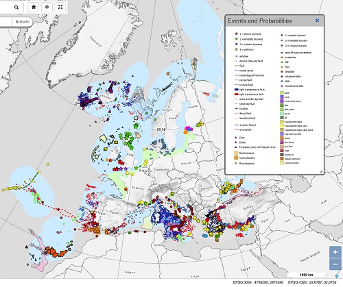
EMODnet GEOLOGY RESULTS (update: april 2019)
The final products of the Project are digital geological maps of the European seas:
- Sea-bed Substrate
- Sea-floor Geology
- Coastal Behaviour
- Geological Events and probabilities
- Mineral Occurrences
- Submerged landscapes
The maps can be downloaded from the EMODnet Geology Portal (http://www.emodnet-geology.eu/).
Work Package 6 “Geological events and probabilities”, led by the Geological Survey of Italy, represents data at different scales (1: 1,000,000; 1: 250,000; 1: 100,000) as polygons, lines and points. The use of different geometric features is related to the peculiar characteristics of each occurrence, as well as to the scale of representation:
- submarine landslides (lines, polygons, points)
- submarine volcanoes (lines, polygons, points)
- tsunamis origin (points)
- tsunamis affected coasts (points)
- submarine tectonics (lines)
- submarine fluid emissions of non volcanic origin (polygons, points)
Regarding earthquakes, it was decided to rely on the Seismic Portal of the European-Mediterranean Seismological Centre (EMSC) web-service (http://www.seismicportal.eu/), which gathers data supplied by national and international networks. Subsequently, upon request of a few Partners, seismic events that are not included in the EMSC portal (because filtered by its system which applies a very strict automated protocol) have been included, because they are considered relevant at local level.
Data sources include detailed information held by the Project Partners plus any further publicly available third-party data (last update April 2019).
All products delivered by Partners have been collected, verified and validated in order to achieve the best degree of harmonization and INSPIRE compliance. In order to obtain such products, specific guidelines to organize data at national level have been elaborated and circulated to Partners. In addition to the localization and classification of the events represented and their references (mandatory), other fields (optional) were provided in order to keep as detailed information as possible for further applications.
All products delivered by Partners have been collected, verified and validated in order to achieve the best degree of harmonization and INSPIRE compliance. In order to obtain such products, specific guidelines to organize data at national level have been elaborated and circulated to Partners. In addition to the localization and classification of the events represented and their references (mandatory), other fields (optional) were provided in order to keep as detailed information as possible for further applications.
 |
|---|
Last update: April 23rd 2020