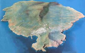
Geological Map of the Island of Ustica

Following guidelines of the new Geological Map of Italy, the survey (carried out on a scale of 1:10,000) tried a different approach for the stratigraphic reconstruction of the area. It did this through the application of unconformity-bounded stratigraphic units (UBSUs) and morpho-stratigraphic units (lithosomes) combined with traditional lithostratigraphic units. UBSUs, which can also include other types of stratigraphic units, enable a synthesis of space and time relations that take place between mapped units and their eventual connection with morphogenetic and tectonic or volcanic-tectonic stages. This can be deduced by considering the important discontinuities (such as paleosoils, unconformity, erosive surfaces, etc.) that mark the area’s history and the evolution of its eruptive system. The volcanic island of Ustica is the remaining part of a seamount’s peak that emerged from the waters of the Tyrrhenian Sea. Its geological history includes an emersion stage with a subsequent evolution as coastal and subaerial environment. It shows pillow-lavas, hyaloclasta and volcanoclastic facies (which are typical of the interaction between magma and water) as well as subaerial lava flows. The numerous lava flows with a basic composition (after a long quiescence interval) were associated to trachytic products (even pumice blocks) of explosive eruptions, which caused the destruction of the Northern part of the island. This depression was later filled in by several lava flows. Furthermore, several dike systems created further volcanic activities in various parts of the island, where tectonic tension features are found. The volcanic activity continued for about 600,000 years in the Middle and Upper Pleistocene with different emission points and changes in the geometry of the superficial eruptive system. When euptive events ended, marine erosion processes became predominant over the island’s constructive ones. The current morphology shows an intense marine abrasion, which has contributed to cancelling the original volcanic forms but has, at the same time, exposed magnificent sections of great beauty and interest.
