Geological map of the Italian sea at the scale 1 to 250000
As part of the CARG project and in accordance with Law 183/89, and also considering the importance of the geological knowledge of the deeper structures through the identification, study and the representation of the Italian continental platform and of the main geological structures of seabeds, the Geological Survey of Italy has launched a project of marine geological mapping of the Adriatic sea, at the scale 1:250,000, in collaboration with the Institute of Marine Geology CNR-ISMAR of Bologna.
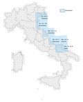
The following sheets were realized:
- NL -33-10 - Ravenna and the definition of methodologies and criteria for the realization of the marine geological mapping at 1:250,000 scale, to which it refers, published in the Booklets, Series III, No. 8, of SGI entitled "Geological Map of the Italian seas at the scale 1:250.000. Guide to mapping;
- NL-33-7-Venice;
- NK-33-1/2- Ancona (which includes, between the meridians 13° and 15°, the eastern half of the sheet NK-33-1 and the western half of Sheet NK 33-2);
- NK-33-5 - Pescara;
- NK-33-6 - Vieste;
- NK-33-8 / 9 - Bari (which includes, between the meridians of 15° and 17°, the eastern half of the NK-sheet 33-8 and western half of the NK-Sheet 33-9).
The sheets are on sale at ISPRA and can be consulted at the ISPRA Library.