Geological map at 1:1.250.000 scale
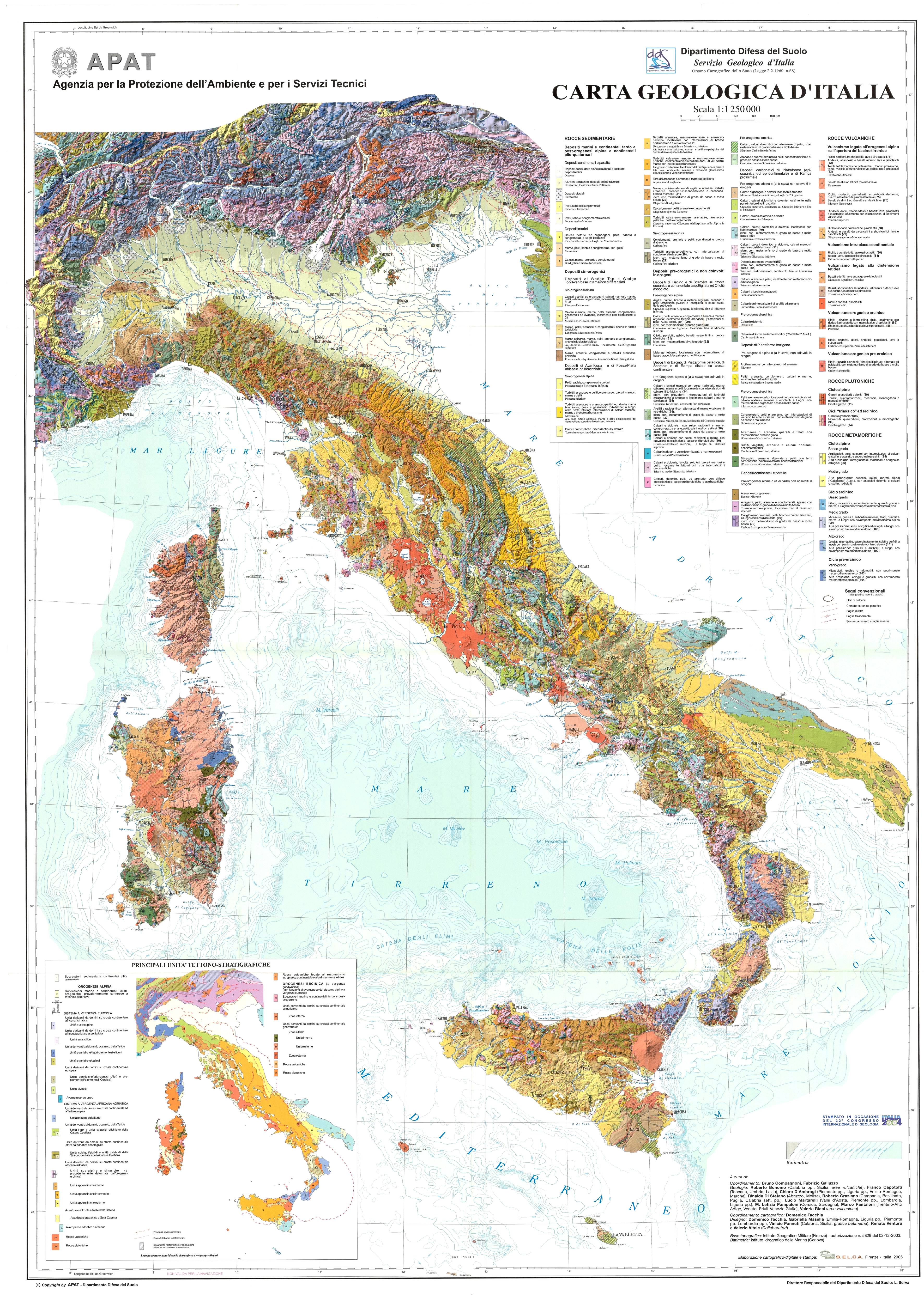
 The Geological Survey of Italy/Land Resources and Soil Protection Department - realized, on the occasion of the 32nd IGC, the Geological Map of Italy 1:1,250,000 scale based on the re-elaboration of a new geological map at 1:500,000 scale.
The main innovation of this Geological Map of Italy is the use of the geological data acquired within the National Geological Mapping project (CARG project) developed at 1:50,000 scale, based on the most recent detailed geological surveys. In areas not yet covered by the new CARG project survey, geological information has been taken from the previous edition of the official 1:100,000 scale geological map of Italy or from the most recent publications available in scientific literature.
Into the realization of the 1:1,250,000 scale Geological Map of Italy has been adopted original criteria, based on a subdivision by orogenic cycles and geological events.
In particular, for sedimentary sequences, the legend has been structured based on a litho-chronostratigraphic subdivision related with geodynamic events and subsequently considering the different paleogeographic environments.
The volcanic units were subdivided taking into account the geodynamic context to which the volcanic processes are referred. Within each group, the chemical nature or the petrogenetic affinity of the rocks was chosen as a criterion for further differentiation; at last, the age of the volcanic emplacement was a tool for distinguishing the rocks belonging to the same type of volcanism and with similar petrographic characters.
Intrusive units have been divided into two main categories based on the age of emplacement, and then grouped according to the petrographic characters related to the magmatic evolution.
Finally, for metamorphic rocks, a first distinction was made on the basis of the metamorphic event age and, subsequently, grouped according to the metamorphic grade and for any possible pressure overprint; when the protolite was still recognizable, the same units were assimilated to the original rock.
This small scale geological map represents a key synthesis of the geodynamic evolution of the peninsula, in parallel with a traditional lithostratigraphic key "reading".
The synthesis procedure developed in this work has also highlighted the geographical and geological areas for which it is essential to develop studies and researches aimed at a deepening of Italian peninsula geological evolution.