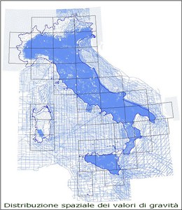
The gravity dataset
The provided observed gravity data, hosted in a geographic database, was referred to IGSN71 and the Bouguer Anomalies were computed with a correction density of 2.67 g/cm3.
The processing flow had the following items:
- Theoretical gravity computation with GRS80 parameters
- Eotvos correction for marine surface data
- Second order Free Air correction
- Bouguer correction using a spherical cap extended to 166.7 km
- Topographic correction with the following Digital Elevation Models: 20m DEM of IGM from 0 to 250 m; DEM 7.5" * 10" of OGS from 250 m to 166.7 km
- The topographic correction takes in account the Earth curvature.
The editing of the Bouguer Anomalies was targeted to noise removal due to discrepancies, artifacts or input errors obvious at the mapping scale level and Quality control routines were applied using also GIS functionalities and grid cross-validation. The result is an homogeneous data set, at 1: 250000 scale, of over 360000 gravity points for the whole italian territory and surrounding seas.
The final data has been interpolated on a regular grid of 1 Km spacing using a Kriging algorithm and conservative, spatially varying, low pass filters were applied for residual noise removal, avoiding map border effects.

