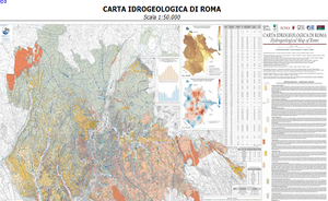
The Hydrogeological Map of Rome adopted among the geological management documents of the General Zoning Plan of the city
The administration of Roma Capitale has adopted the geological and hydrogeological maps, also produced by ISPRA in cooperation with other Bodies, which update the "Geolithological Map" and the "Hydrogeological Map" of the geological management documents G9 of the General Zoning Plan of Rome.
The Hydrogeological Map of Rome, realized on 2015 thanks to an agreement between the Gelogical Survey of Italy (ISPRA), the Municipality of Rome, the Roma Tre University, the C.E.R.I. Spienza University Research Center, the IGAG institute of National Research Council and the National Institute for Geophisics and Volcanology, already known and used by technicians and experts, represents the most recent information related to the groundwater below the City area. The map is available in the Geological Survey of Italy website and in the Open Data onlinre repository of the Municipality of Rome.
It shows the identified aquifers, the hydrogeological characteristics of lithologies, the spring flow, and water level and physio-chemical data about the Groundwater Monitoring Network of Rome.
Moreover, it reports average rainfall and temperature data about the last 20 years according with the official monitoring network of Latium Region.

