
Geological and Geotematics Map
The Geological Map of Italy at 1:100,000 scale
The Geological Map of Italy at 1:100,000 scale consists of 277 sheets. First surveys started in 1877 and have been completed in 1976. In addition, other 132 sheets have been included with the second edition. All geological sheets, and related explanatory notes, are also printed on paper and available at the ISPRA Library. All sheets, each one provided with its legend and sections, can be viewed both in raster and vector format with the Geomapviewer and are available as OGC services.
Geological Map of Italy at 1:50,000 scale - CARG
The CARG Project (Italian Geological mapping plan) started at the end of the 80s with the aim to complete the Italian geological and geothematic map at 1:50,000 scale, based on detailed (1:10,000 scale) geological field surveys, having an associated geological database (1:25,000 scale) constituted of 14 informative layers. Maps are realized in collaboration with Regions, Autonomous Provinces, Universities and Research Institutes (e.g. CNR). The Geological Sheets of the CARG Project, with legend and geological cross-sections, can be viewed both in raster and vector format with the Geomapviewer and are available as OGC services. Moreover, Geological Sheets and Explanatory notes are printed on paper and on sale at ISPRA or can be consulted at the ISPRA Library.
Geothematic maps of Italy at the 1:50,000 scale
Geothematic sheets of the Geological Map of Italy at the 1:50,000 scale – CARG Project (geomorphological map, hydrogeological map, geological hazard map, slope instability map, flood events map, gravimetric-structural map, geomining map), available for viewing in raster format and within the Geomapviewer, and usable as OGC services
Geological Map of Italy 1:1,000,000 scale
The map derives from a summary of the recent geological Italian cartography starting from the map at the scale 1:100,000 updated with the geological information from CARG project at the scale 1:50,000. Legend shows all the essential data for the stratigraphic characterization of the geological units, the definition of the depositional environments and highlights the main geodynamic events related to the Hercynian and Alpine orogenesis in their different phases. The map can be viewed with the Geomapviewer and is available as OGC services.
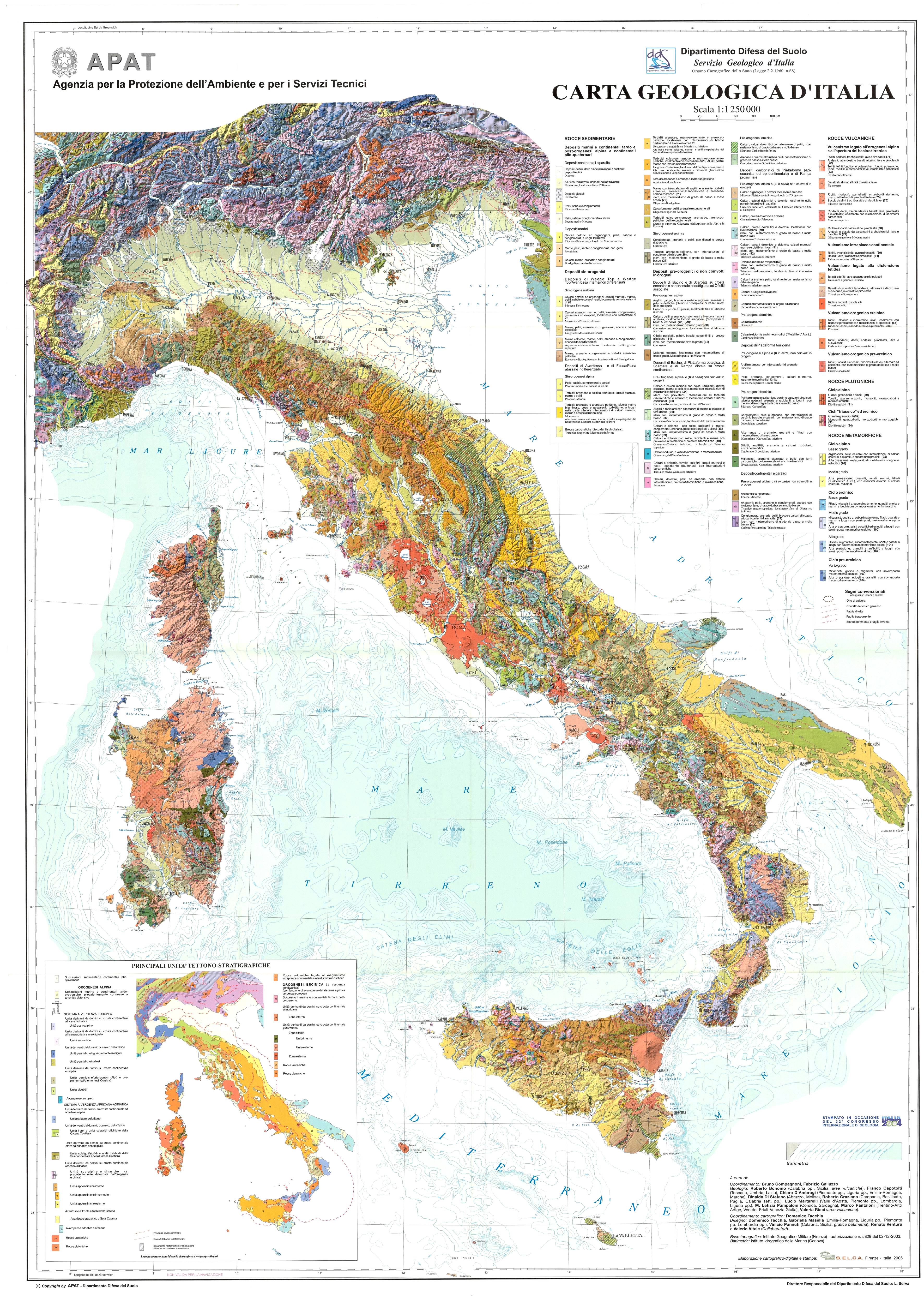
Geological Map of Italy 1:1,250,000 scale
This Map was created in 2004 for the 32nd IGC in Florence, based on the elaboration of the geological map at 1:500,000 scale, representing a new synthetic map to provide information on the geodynamic evolution of the Italian peninsula, in parallel with the traditional lithostratigraphic structure. Original criteria have been adopted for the realization, based on a subdivision by orogenetic cycles and geological events. The map can be viewed in raster format and is available as OGC services.
Geological Map of Italian seas at 1:250,000 scale
The sheets of the Geological Map of Italian seas at 1:250,000 scale of the CARG Project can be viewed as rasters or with the Geomapviewer and are available as OGC services.
Geological map of the world at the 1:1.000.000 - OneGeology
World Geological map at 1:1.000.000 scale, accessible from OneGeology Project Portal. The map has been created through harmonization of National geological maps.
Hydrogeological maps
Hydrogeological maps at different scales and extensions of national interest (Italy, Piemonte Region, Po Valley, Central and Southern Italy). The maps can be managed with Geomapviewer of GSI Portal and is available as OGC services.
Lithological map
The lithological map at 1:100,000 scale is a project of the Geological Survey of Italy aiming to the realization of a uniform map representing the entire territory in greater detail with respect to the existing geological databases at 1:100,000, 1:500,000 and 1:1,000,000 scales. The database contains the classification by lithotypes together with a set of attributes still under validation process: rocks genesis, environment of rock formation, structure of formations, rock structure and texture. The map can be viewed as raster with the Geomapviewer and is available as OGC services.
EMODnet Geology
EMODnet (European Marine Observation and Data Network) is a European project aimed at creating a database of European submerged areas. EMODnet-Geology produces digital maps, at different scales (1:1,000,000; 1:250,000; 1:100,000), of the geological characteristics of seabeds (sediment distribution, substrate geology, coast evolution, geological events, mineral resources) deriving from the harmonisation of the data provided by National Geological Serveys.
ASC database (filed samples and analyses) of the CARG Project
This is a lithological database of rock samples that includes analysis performed during the realization of CARG Project. It includes description of the lithologies and, where possible, results of the sedimentological and paleontological analysis in addition to information on the assemblages and biostratigraphy.
- Link to page (in updating)
- Link to the visualizer (in updating)
3D geological models at different scales and coverages, based on geological cross-sections, stratigraphies of shallow and deep wells, seismic reflections profiles, isobates of the substrate. Subsurface maps derived from 3D models are viewable with the Thematic Viewer.
Geological Field Trips
Access tool to geological itineraries published by the “Geological Field Trips and Maps” journal edited by ISPRA and the Italian Geological Society.