Menù di utilità
| Menù di navigazione principale
|
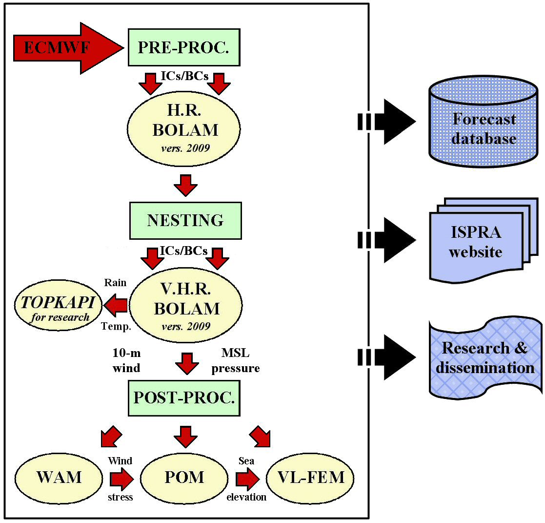
Home / Hydro-Meteo-Marine forecasting System Hydro-Meteo-Marine forecasting SystemLast update: 29/10/2019 Forecasting meteo-hydrological and marine conditions over the Mediterranean basin addresses specific challenges since the atmospheric and marine events affecting this area are characterized by a wide range of interacting scales, spreading from global to local scales. In addition, observations are scarce over the sea and the Northern Africa region, and only in the recent times this problem is mitigated by the increasing availability of satellite observations. The development of the Hydro-Meteo-Marine forecasting System (SIMM - Sistema Idro-Meteo-Mare) by the former Italian National Department for Technical Services (now partially merged into ISPRA) and ENEA was at the end of nineties a state-of-the-art response to those challenges. The key strength of the SIMM system was the integration between meteorological and marine modelling over the entirety of the Mediterranean basin, running at the hydrostatic limit resolution (10 km). Core to the original integrated forecasting SIMM, which became operational in 2000, was a sequence of four different models: a parallel configuration of the BOLAM model (where the 2009 version of the model replaced later the original version named QBOLAM) for meteorological forecast over the Mediterranean basin, the WAM model for sea-state forecast over the Mediterranean Sea, the POM and VL-FEM models for sea surface elevation over the AdriaticIonian Sea and the Venice Lagoon, respectively. In a research configuration, the TOPKAPI hydrological model has been integrated into the system, coupled to BOLAM, to provide hydrological forecasts over the Italian Adige and Reno river basins.
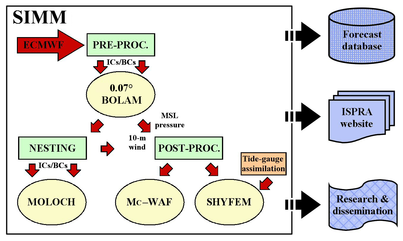
ORIGINAL CHAIN OF THE HYDRO-METEO-MARINE FORECASTING SYSTEM (no more operational). Following a robust and continuous forecast verification activity, which is reported in several papers and presentations available in the "Publications and presentations" session, several updating campaigns of the SIMM forecasting system have been conducted during these years. As a result, some components of the system have been replaced with modules suitable to increase both computational efficiency and forecast quality. Since September 2015, it is operational the new SIMM that includes three forecasting components. The meteorological component is at the head of the forecasting chain. At present, it is operational the meteorological configuration developed for the activities of the international initiative HyMeX - HYdrological cycle in the Mediterranean EXperiment (see below) that is based on a 0.07° BOLAM coupled with a very high resolution (0.0225°) configuration of the convection-permitting non-hydrostatic MOLOCH model. This configuration is operational on a High Performance Computing (HPC) cluster (16 HP SL230s Gen8 nodes, 256 core). Originally, the SIMM meteorological component included, instead, a BOLAM parallel version one-way nested over two domains, namely H.R BOLAM at 0.3° (ca. 33 km) and V.H.R. BOLAM at 0.1° (ca. 11 km); The second component of SIMM is provided by the Mediterranean-embedded Coastal WAve Forecasting system (Mc-WAF) which provides wind-generated wave forecasts at Mediterranean (1/30 deg. res.), regional (1/60 deg. res.) and coastal (1/240 deg. res.) scale. The meteorological input for Mc-WAF is provided by the BOLAM-MOLOCH suite. This component, which is also implemented on the HPC cluster, has replaced the WAM model present in the original SIMM configuration. The third component is a version over the Venice Lagoon of the Shallow water HYdrodynamic Finite Element Model (SHYFEM), which is an updated and improved version of the VL-FEM model and it is directly coupled with the 0.07° BOLAM model. The current SIMM chain, deploying the BOLAM-MOLOCH system as meteorological component, has been initially developed for the forecasting activities foreseen and carried out in the framework of the HyMeX. Then, it becomes operational after being tested and verified over several test cases of meteo-marine intense and severe events and over the September 2012March 2013 period, which covers the two HyMeX observational campaigns named SOPs - Special Observation Periods. The SIMM chain deploying a meteorological component based on BOLAM running on two one-way nested grids was mantained as a legacy of the original system until the beginning of September 2019.
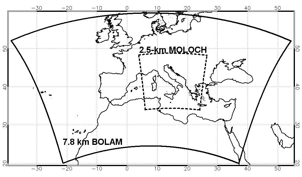
CHAIN OF THE OPERATIONAL HYDRO-METEO-MARINE FORECASTING SYSTEM, BECOME OPERATIONAL AFTER THE HYMEX INITIATIVE. BOLAMThe BOlogna Limited Area Model (BOLAM) is a hydrostatic finite difference model developed by the Bologna branch of ISAC-CNR. Within the original SIMM chain, a parallel version of BOLAM was initially implemented on a 128-processor QUADRICS parallel machine, hence the initial name QBOLAM; then, in 2005 the model was implemented on a SGI-Altix machine. In 2011, it was implemented on that machine an updated code version of the model that included more advanced parameterisation schemes for cumulus convection, radiation, soil and exchange of turbulent fluxes and used the explicit advection of five hydrometeors. The meteorological component that is now operational in the SIMM forecasting system is instead based on a further updated version of BOLAM, dated 2019, covering a wider domain with a grid mesh size of 0.07° (see figure below). Analyses and forecasts provided by the 0000 UTC and 1200 UTC runs of the European Centre for Medium-Range Weather Forecasts (ECMWF) Integrated Forecasting System (IFS) are directly applied as initial and boundary conditions to BOLAM without using a coarser-resolution father model run. These analyses and forecasts have a higher spatial and temporal resolutions with respect to the ones originaly deployed in SIMM. The BOLAM operational configuration is implemented on a HPC high performance computing cluster with 16 nodes, 256 core. 132-h forecasts for several surface and level fields (all at hourly time scale) are available in the "0.07° BOLAM forecasts over the Mediterranean Basin" session. MOLOCHIn the framework of the HyMeX initiative, the non-hydrostatic MOLOCH model, also developed by ISAC-CNR, was nested into the 0.07° BOLAM run to produce higher-resolution forecasts with a grid mesh size of 0.0225° (2.5 km), mainly covering northern and central Italy. This domain was chosen to include at least five of the eight hydrometeorological sites monitored during the HyMeX SOPs and to reduce computational cost, as well. When the BOLAM-MOLOCH suite has become operational, the MOLOCH domain has been extended to cover the entirety of Italy (approximately 4934° N e 525° E, as depicted in the figure below). Currently, 84-h forecasts provided at hourly time scale by the 2019 version of MOLOCH are available in the "MOLOCH forecasts over Italy" session.
DOMAINS OF THE NEW METEOROLOGICAL COMPONENT OF THE HYDRO-METEO-MARINE FORECASTING SYSTEM. WAMThe spectral WAve Model (WAM), which was present in the original configuration of the SIMM chain, was used to produce 84-h forecasts of significant wave height and direction over the Mediterranean Sea with a horizontal grid spacing of 0.1°, using as forcing the BOLAM wind forecasts. WAM describes the evolution of the wave spectrum by solving the wave energy transfer equation. The resolution (0.1°) of the wind forecast fields used as forcing represented in the late 90s the strong point of the WAM model. Mc-WAFIn the last years, ISPRA has developed and operationally implemented the Mediterranean-embedded Coastal WAve Forecasting system (Mc-WAF) that, forced by the wind forecasts modelled by BOLAM and MOLOCH, produces sea state forecasts over the Mediterranean Sea and over selected Italian coastal areas. The Mc-WAF system adopts a third generation version of the WAM model and it works on three levels of nesting: from the Mediterranean scale to the coastal scale, passing trough the regional scale. The operational system starts with a basin scale grid at a resolution of 1/30 degree. On this large scale grid nine regional areas at a resolution of 1/60 degree are nested. On two of the regional grids, six coastal areas are nested at a resolution of 1/240 degree. For the runs at the Mediterranean scale, the meteorological input is provided by the 0.07° BOLAM, whereas it is provided by MOLOCH for the regional and coastal runs. Wind-generated wave forecasts are daily available in the "Sea state forecasts" session. POM and VL-FEMIn the original SIMM chain, the Princeton Ocean Model (POM) was used in a shallow-water configuration to predict surface elevation fields over the Adriatic-Ionian Sea. POM was driven by the WAM surface wind stress fields and the BOLAM sea level pressure fields. Sea level data at the three entrances of the Venice Lagoon provided by POM, and the WAM surface wind stress within the Venice Lagoon were used to force the Venice Lagoon-Finite Element Model (VL-FEM): a finite element, very high-resolution model that was used to predict water flow within the Venice Lagoon. SHYFEMMore recently, a new
storm-surge forecasting component has been developed and implemented for the Venice Lagoon.
This component is obtained by directly forcing the Shallow water HYdrodynamic Finite Element Model
(SHYFEM) developed by the Venice
branch of the Institute of Marine Sciences
of CNR (ISMAR-CNR) with the wind and mean sea level pressure
fields generated from 0.07° BOLAM, including also the possibility to
assimilate the residual sea level measurements from the tide gauges of the
ISPRA observation network (RMLV
- Rete
Mareografica della Laguna di Venezia e del Litorale Nord-Adriatico)
located alongside the Italian northern Adriatic coastline. The model is
also forced using meteorological fields provide by ECMWF
IFS.
SHYFEM forecasts together with forecasts produced with an ad hoc statistical
model are used by ISPRA to produce daily Tide
Bulletin for the Venice Lagoon. The use of the Hydro-Meteo-Marine forecasting System products (2000-2019)Since 2000, daily forecasts produced by SIMM have been deployed for ISPRA institutional purposes related to environmental monitoring, numerical modelling, development of technical and scientific know-how, and data sharing in the framework of the Italian National System for Environmental Protection. The fields of interest are: water resources, intense and severe hydro-meteorological and meteo-marine events, coastal protection, integrating and merging data from different measurement networks, navigation, etc. Besides the use of SIMM products in the framework of the usual collaboration with the regional environmental agencies (ARPA and APPA) of the Italian National System for Environmental Protection, and with analogous European institutes and agencies, SIMM products have been also used in research contexts in collaboration with the national and international scientific communities and in several European projects and International initiatives (INTERREG II C “drought” and “floods”, HYDROPTIMET, FP5-VOLTAIRE, SEDEMED, SEDEMED 2, NETWET 2, FORALPS, MEDEX, HYDROCARE, MIPAIS, MAP D-PHASE, ERA-Net CRUE, HyMeX and MesoVICT). Among the aims of the use of the SIMM products it is worth mentioning: the development of verification methodologies (for both operational and research uses) of meteo-marine models by comparing forecasts against observed data; the analysis of hazard events over the Mediterranean basin (floods, storm surge events, etc.) and their phenomenology (Mediterranean cyclones, statistical analysis of extreme events, etc.); the assessment of water resources; the use of coupled hydro-meteorological models for flood prediction; the multi-sensor precipitation field estimation; the optimisation of shipping routes on the basis of meteo-marine conditions (weather-routing); the evaluation of wind resources at Mediterranean offshore sites; the protection against oil spill events; and the support to institutional monitoring operations. An example of these latter activities can be given by the Italian Bahar environmental mission in Lebanon in 2006, when the Department of Inland and Marine Waters Protection contributed daily to the mission by making available via web the SIMM wind and sea state forecasts for the monitored area and by providing with an internal task force a meteo-marine bulletin to support the clean-up activities. At the beginning of 2012, the SIMM forecasts, together with the observations recorded by the Italian national tide gauge network (RMN - Rete Mareografica Nazionale) and by the Italian national wind wave buoy network (RON - Rete Ondametrica Nazionale), were used for monitoring activities in the framework of the environmental emergency in Isola del Giglio due to the Italian cruise ship Costa Concordia accident on 13 January 2012. From the scientific point of view, it is worth to remind that ISPRA, through the Department of Inland and Marine Waters Protection, contributed to the two HyMeX SOP - Special Observation Period campaigns occurred at the turn of 2013 (5 September-6 November 2012 & 1 February-15 March 2013) by providing forecasts from the 0.3° BOLAM (reported as BOLAM-D2 in SOP) and 0.1° BOLAM (reported as BOLAM-D3 in SOP), as well forecasts from the 0.07° BOLAM (reported as BOLAM-D4 in SOP) and the 0.0225° MOLOCH (reported as MOLOCH-ISPRA in SOP) that were ad-hoc developed for these monitoring campaigns. The following meteorological fields (maps and grib files) were made available: 500- hPa geopotential height; height of the 1.5 potential vorticity; CAPE; total water content; accumulated precipitation at 1, 3, 6, 12 e 24 hours; mean sea level pressure; relative humidity; 2-m temperature; equivalent potential temperature (theta E); wind at 10 m and at 250, 300, 600 e 925 hPa; potential vorticity. In that framework, it was also initially tested the use of the 0.07° BOLAM and the 0.0225° MOLOCH to force the Mc-WAF system and the SHYFEM model. A selection of publications and presentations having as topics the Hydro-Meteo-Marine forecasting System and the related activities are available in the "Publications and presentations" session.
Additional information about the Hydro-Meteo-Marine forecasting System can be requested to: simm-pre-meteo@isprambiente.gov.it.
|