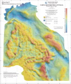
The Gravity Map at 1 to 1250000
 A new gravity map of Italy at 1:1.250.000 scale has been compiled using land and offshore data extracted respectively from the Italian Agency for Environmental Protection and Technical Services (APAT) - Land Resources and Soil Protection Dept. and the Italian National Institute for Oceanography and Experimental Geophysics (OGS) databases. The whole original gravity data has been re-corrected using the IGSN-71 (International Gravity Standardization Net) net as reference and the 1980 formula to compute the normal gravity. For the onshore data, Bouguer anomaly has been computed using a nominal density of 2.67 g/cm3; the terrain correction has been computed up to a radius of 166.736 km. On the marine data, most of them acquired along survey lines, the processing consisted in the computation of Free-air anomaly only. The gridded database is produced interpolating the merged onshore and offshore dataset onto a 1 km node spacing square grid; the resulting map is based on the contouring of this grid. The map offers detailed gravity information for geophysical studies related to subsurface geology and medium-scale tectonic features in Italy; it can be considered as a valuable tool for identifying major structural lineaments and outlines geologic bodies at a regional scale.
For further information: Dr. Fernando Ferri

